

A day on the lanes is rarely one long ride. It's a lane, some tarmac, another lane, a fuel stop, and a look at the sky wondering how muddy it'll be. This update is built around that kind of day: a way to ride a planned route one lane at a time, a log of what you rode with a card to share, fuel stations on the map, a mud forecast for every unpaved lane, and a smarter Legal Status Search.
Ride a planned route, lane by lane
Plenty of riders don't want a moving map on the bars. They want Google Maps to handle the roads, then to ride each lane themselves. "Navigate lane by lane" is built for that. Plan your route as normal, then open it as a list of big, easy-to-tap cards, one per lane. Each card shows which end you'll head into, and the arrows button swaps it if you'd rather ride it the other way. Tap a card and Google Maps takes you to that lane's entrance. Ride it, come back, tap the next one.
At the top of the list there's now a big green Start ride button. Tap it before you set off and Holloway keeps track as you go, with a running count like "2 of 5 lanes, 1h 10m". When you're done, the button turns into a red Finish ride.

Mid-ride: the red Finish ride button, your progress, and the next lane waiting. Shown with a sample ride.
Navigate lane by lane is part of Holloway Premium, along with route planning and live navigation.
Log your ride, then share it
When you finish, you get a list of every lane in the route. The ones you navigated to are already ticked, and the rest are there unticked, so a lane you rode without tapping its card is one tick away. Untick anything you skipped and mark the rest as ridden in one go. They go straight into your ridden lanes, and onto your account if you're signed in.
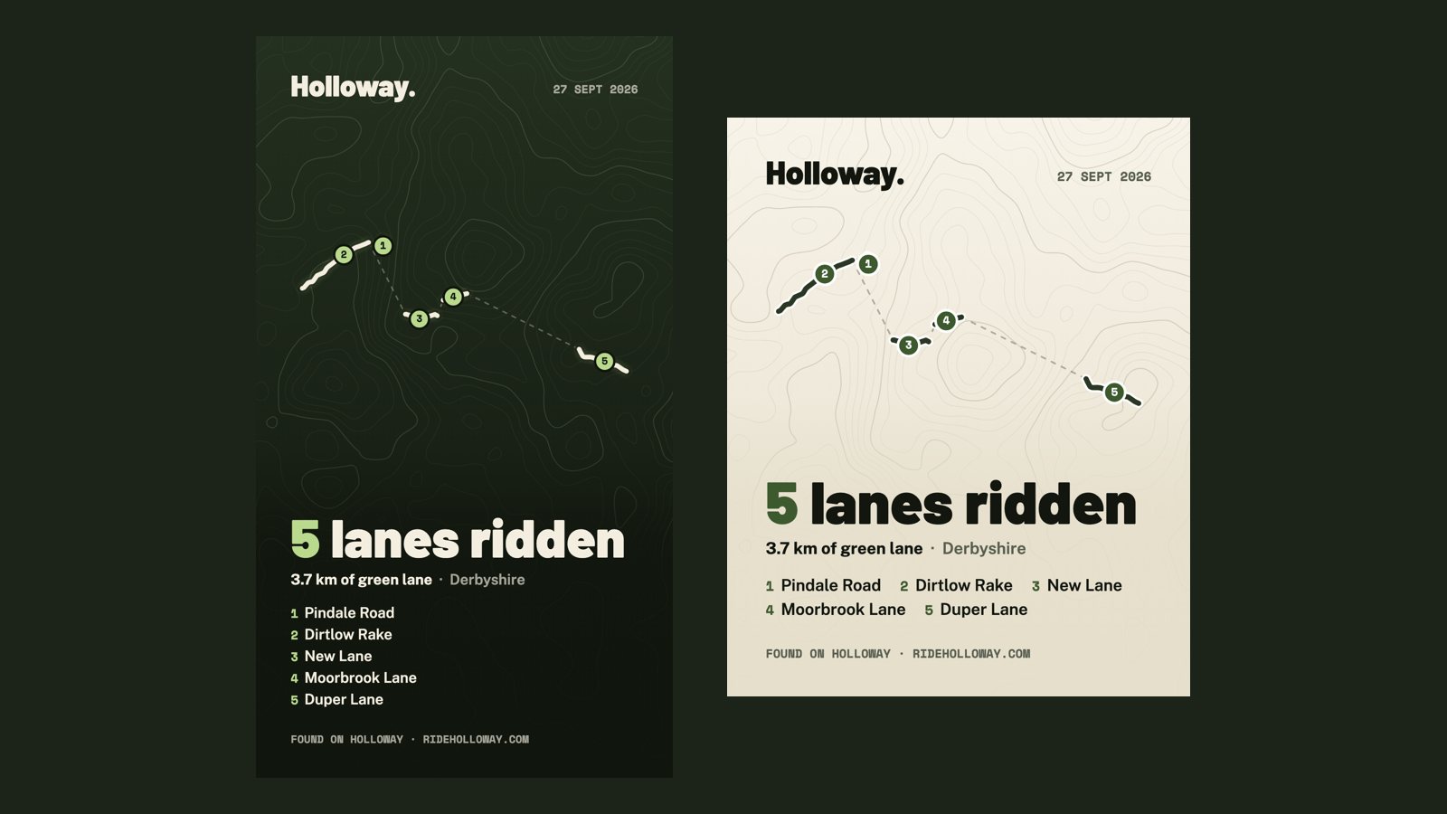
Then make a share card. It draws the lanes you rode over a contour-map background, numbered in the order you rode them, with a big "5 lanes ridden" headline, your distance on green lanes, the county and the lane names. Choose a tall size for Instagram Stories or a shorter one for a post, dark or light. Tap Share and your phone's own share menu opens, so it goes straight to Instagram, Facebook or WhatsApp. Or just download it.
The card is drawn without a real map underneath on purpose, so it never shows exactly where you live. The distance is your mileage on green lanes only: we don't track the roads in between, so the card doesn't claim them.
The ride log and share card are free. You don't need a planned route either. Start a ride log from the Menu, and add lanes from their cards as you go. With Premium, any lane you tap Navigate on is added for you.
Fuel stations on the map
Running low halfway through a day in the hills is no fun. Tick "Show fuel stations" in the sidebar and zoom in, and nearly 8,000 fuel stations appear across England, Wales and Scotland. Tap one for its brand, address, whether it's open 24 hours where that's known, and a button to navigate there. While planning a route, tap a station to add it as a stop, and it's included in your GPX file.

Tap a station for its details and one-tap directions.
The stations come from OpenStreetMap, mapped by volunteers. We don't have prices, and rural stations can close or keep short hours, so check before you rely on one for a long ride. Fuel stations are free for everyone.
A mud forecast for every unpaved lane
"Will it be muddy?" is the question every rider asks before a lane, and until now the answer was a guess. Open an unpaved lane and, below the weather, you'll now see a quick verdict on the ground: likely dry, damp in places, wet, expect mud, or very wet, deep mud likely, with the rain over the last three days and the next 24 hours.
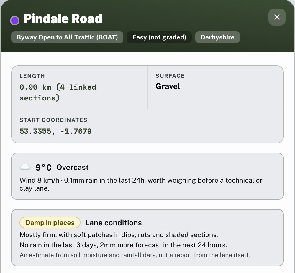
The mud forecast sits under the weather on every unpaved lane.
It's based on soil moisture data for that spot. We tuned it against a year of readings from very different ground, from Bedfordshire clay and Salisbury Plain chalk to Dartmoor and Norfolk sand, so a wet winter reads as wet wherever you are. If the lane has a ford and there's been a lot of rain, it warns you that the ford may be running high. It's an estimate from weather data, not a report from the lane itself, so a shaded or sunken lane can stay wetter than it says. The mud forecast is part of Holloway Premium.
While we were at it, we fixed the weather box's rain figure. It had been adding up about 48 hours, including rain that hadn't fallen yet. It now shows the last 24 hours.
A smarter Legal Status Search
Every lane has a free Legal Status Search, a one-tap Google search for any current Traffic Regulation Order. For unnamed lanes it often came back with "I cannot give a definitive answer", because all it had to go on was "this BOAT in Northamptonshire". Now it names the nearest village, asks whether any order affects motorcycles, and asks which other byway TROs the council has in force.
We tested it on an unnamed byway near Dodford. Before, Google couldn't say anything useful. Now it names the byway, names the council, and says motorcycles are exempt from its winter closure, which is exactly what a rider needs to know. It's still a starting point rather than the final word, so check signs and the council's own notices before you ride.
Tell us what to build next
Most of this came from riders telling us how they actually ride. If there's something that would make your days on the lanes easier, tell us. You can reach us from the Menu in Holloway, or on Facebook and Instagram.
New to the app? The User Guide walks through everything, and GPX Routes has ready-made routes to try the new ride log on.